
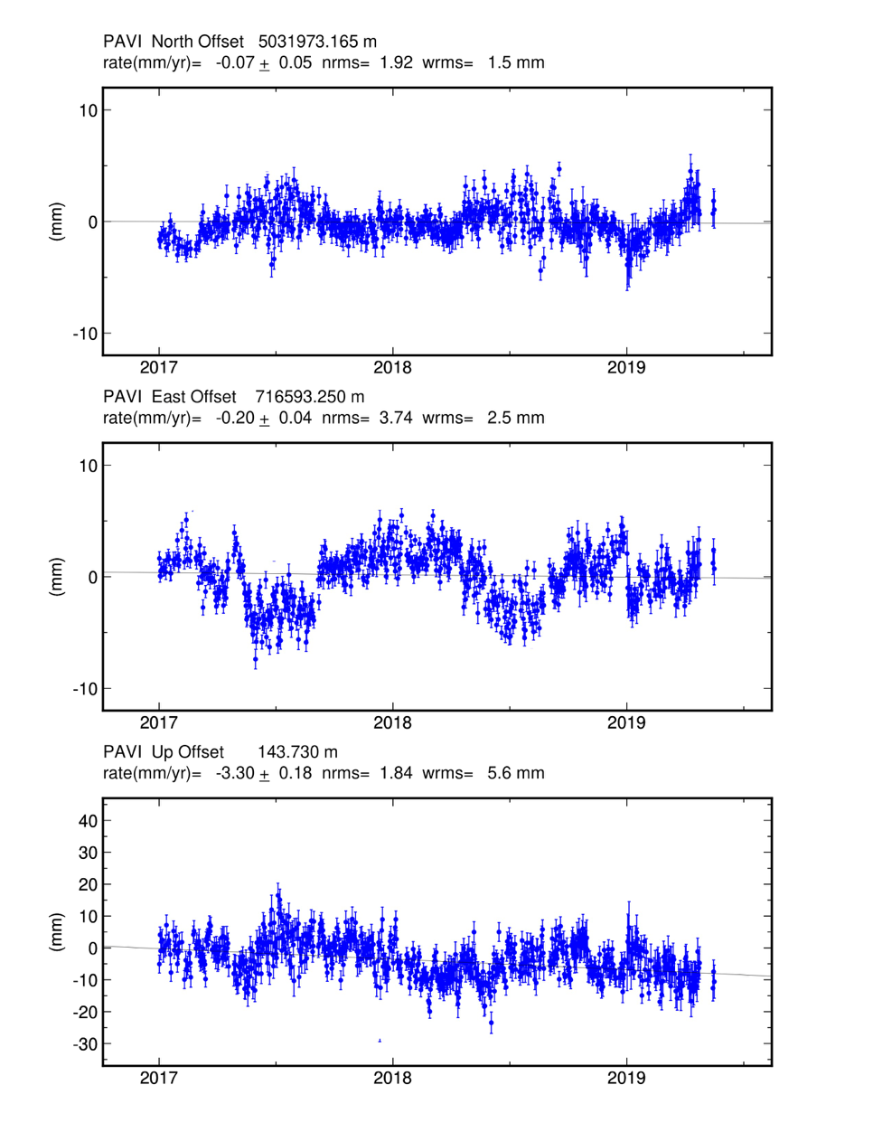
Below are the estimated time series for each Lodi GNSS network site for the time period 1/1/2017 - 31/05/2019. The series are available in two different reference systems: the international one (ITRF08, see description in the “Reports” section) and the European one (EURA, Figures 1-5). In the international system, the displacements and velocities are estimated with respect to a geocentric inertial system that makes evident the motions related to continental drift; these rates are quite important, and, for example, for the horizontal component, they are tens of mm/year for all GPS sites. In the EURA system (Altamimi et al., 2012) the displacements are estimated compared to the European block (or Eurasia), where the average motion of the European plate is subtracted from each site in the network. In the EURA system, therefore, the displacements are significantly smaller than those in the ITRF system, and for example, the rate in the horizontal plane is reduced to a few mm/year. The time series graphs allow a more detailed analysis of the behaviour of each GPS station; this gives an estimate of the movement of the station before the storage activity.
Comparing the Lodi GNSS network station series, a congruent trend between the ITRF and EURA systems can be seen. In particular, the behaviour of the OL01 station, especially in the UP direction, is similar to those of the CREA, CREM, MILA and PAVI stations; this factor shows that the data and related measurements from the OL01 station are representative for a large part of the territory where the station is installed. Table 1 shows the strain rate estimates for the 5 stations in the reference frame. In the ITRF reference system, where much more pronounced displacements are expected, the values are similar for all GNSS stations (from 16.25 mm/year to 17.26 mm/year in the North coordinate and from 18.95 mm/year to 20.84 mm/year in the East coordinate) and deviate very little from those estimated in the previous report.
| ITRF08 | EURA | |||||
|---|---|---|---|---|---|---|
| Vel. Nord [mm/anno] | Vel. Est [mm/anno] | Vel. Up [mm/anno] | Vel. Nord [mm/anno] | Vel. Est [mm/anno] | Vel. Up [mm/anno] | |
| OL01 | 17.26 | 18.95 | -3.40 | 1.25 | -1.96 | -4.28 |
| CREA | 16.25 | 20.61 | -2.53 | -0.03 | -0.24 | -3.35 |
| CREM | 16.61 | 20.84 | -2.31 | 0.29 | -0.12 | -3.07 |
| MILA | 16.49 | 20.10 | -1.43 | 0.10 | -0.61 | -2.18 |
| PAVI | 16.38 | 20.53 | -2.46 | -0.07 | -0.20 | -3.30 |
For the Eurasian reference (EURA), the rate estimates of the OL01 station have to be considered preliminary for two main reasons. The first reason is that the available data are not yet sufficient for a reliable estimation of such low strain rates. Therefore, it is necessary to have a longer observation period. The second reason is that the site is newly built and the time interval for which data are available is within the period of stabilization of the monument. The rate in the UP direction does not change in the two reference systems ITRF and EURA and fluctuates between -1.43 mm/year (MILA) and -4.28 mm/year (OL01). The results obtained to date related to the analysed stations (Lodi GNSS network) will allow, through comparisons with the CREA, CREM, MILA and PAVI stations, evaluation of the strictly local variations in the movements of the OL01 station.
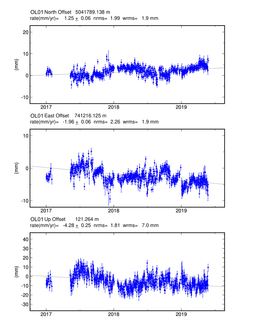
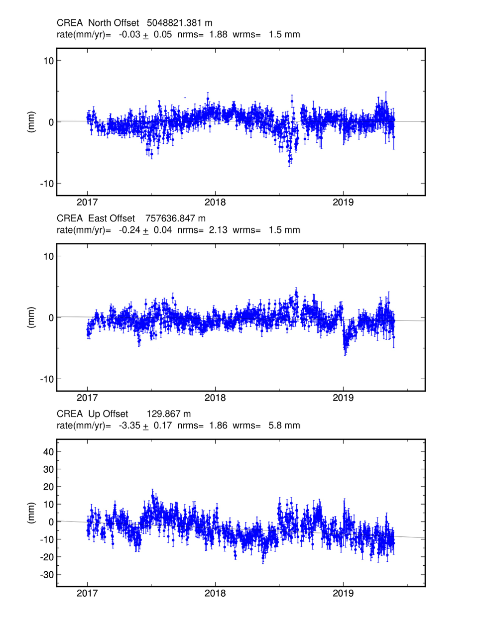
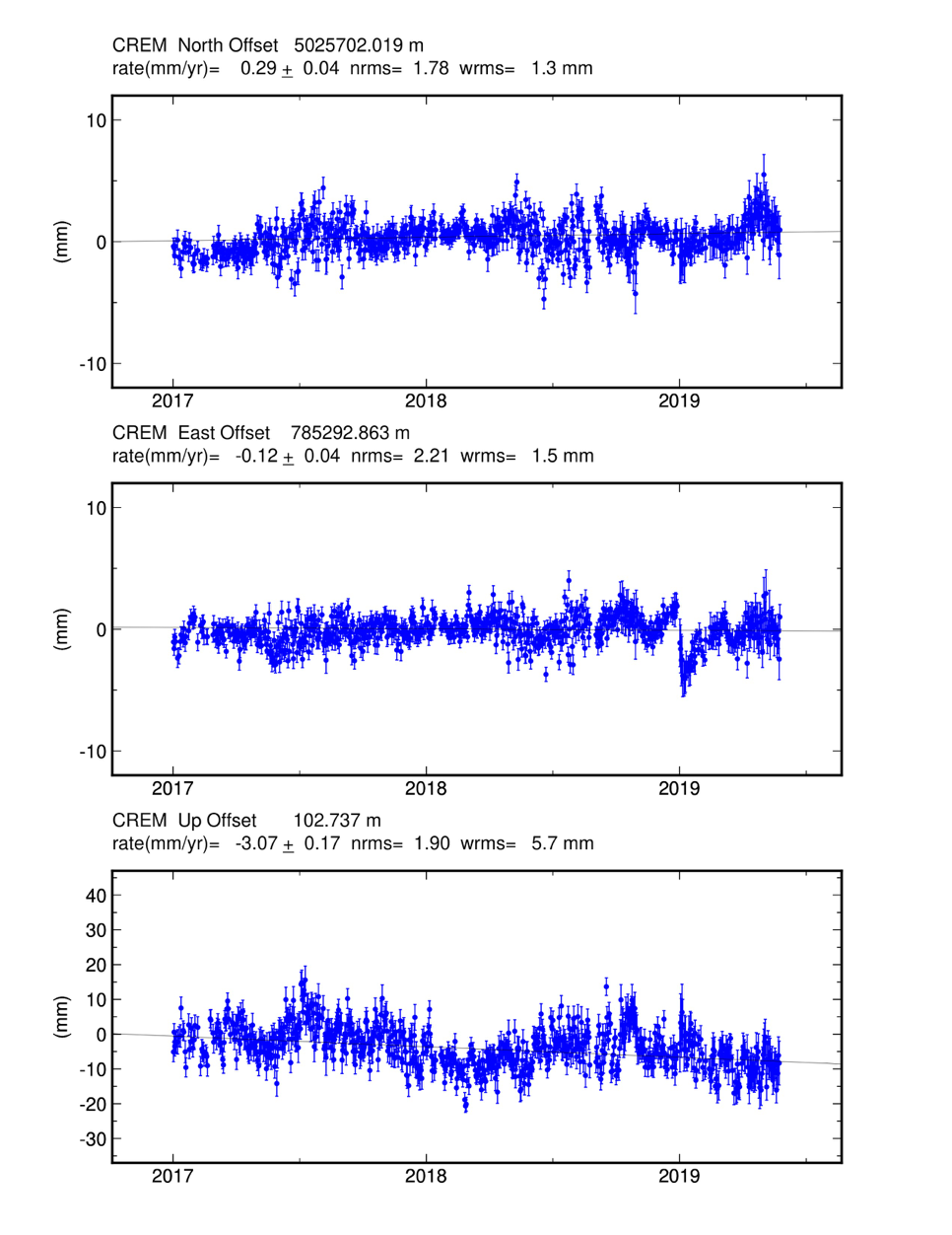
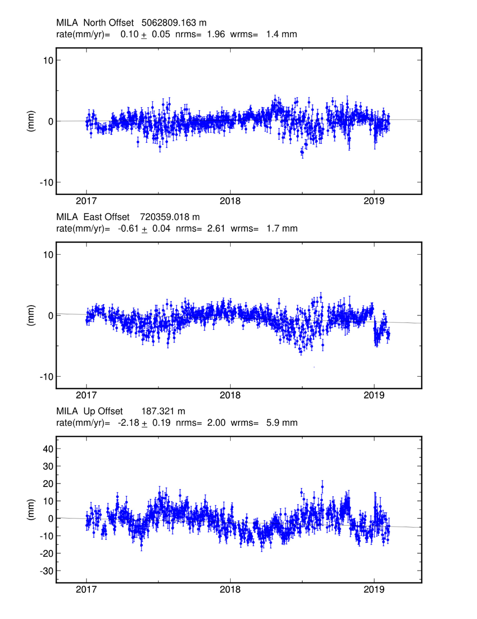
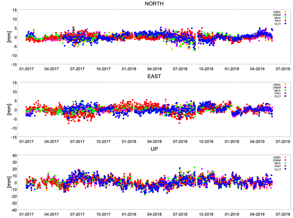
A last comparison (Figure 6) is made comparing the five stations OL01, CREA, CREM, MILA and PAVI; in particular, the time series of rates in the different components have been compared by removing from each one its previously calculated trend (compared to the EURA reference system). Figure 6 shows the marked local variations and shifts using the net of each rate. The diagram illustrates that regarding the displacements on the plane and in elevation, all five sites behave in the same way; the trends of the temporal series results are almost overlapping, and significant local displacements are not evinced. At the moment, the processing covers only the first interval of storage activity starting on 12/12/2018; the processing of GNSS data from the OL01 station ends on 31/05/2019, and in the first instance, no abnormal elevations of the ground are observed.
GNSS data processing
The OL01 station records, with 1 second sampling, the data coming from the satellites belonging to the GNSS (Global Navigational Satellite System) that orbit the Earth. OL01 data are recorded as RINEX (receiver independent exchange) format files and are processed together with those of other stations of interest to obtain daily estimates of the coordinates of the network stations, called time series, according to two reference systems: the international system ITRF08 (International Terrestrial Reference Frame 2008) and the European system EURA.
The calculation, which includes the estimation of the relative positions of GNSS stations and satellite orbits, is performed with the GAMIT/GLOBK software package developed by the Massachusetts Institute of Technology, Harvard University and the Scripps Institution of Oceanography.
- In the first stage of elaboration, through the GAMIT package, RINEX files are created and processed, which are used for the estimation of the weakly constrained daily solutions: station coordinates, orbits, atmospheric delays, ambiguities and variance covariance matrices of the solutions themselves.
- Subsequently, (with the GLOBK package), the calculation of daily solutions is performed, including some stations belonging to the EPN (EUREF Permanent Network) and IGS (International GNSS Service) in addition to OL01 and the stations of the Lodi GNSS network.
- The daily solutions obtained are then framed in the ITRF08 and EURA reference systems, and the time series are obtained.
The time series represent the trends of the locations of the analysed site. The following factors are taken into account in the analysis of the time series:
- the time series have seasonal trends;
- in the time series, there are annual random signals related to the movements of the GPS monument, signals determined by the hydrology of the site, atmospheric pressure, and temperature variations.
In addition, it is necessary to consider two types of noise: uncorrelated noise (white noise), which introduces random fluctuations with a Gaussian distribution in the solutions, and time-dependent noise (random walk), which includes the effects of small random movements of the monument (usually a pillar that attaches the GNSS antenna to the rock substrate), uncertainties in the parameters of satellite orbits, atmospheric effects and local phenomena.